
Selecting the right wall map depends on the available wall space, the intended use, and the specific cartographic details you require. Whether you need a compact set for a small classroom or a giant single sheet for a large lecture hall, the size and projection style significantly impact the viewing experience.
This guide compares eight distinct wall map options, ranging from compact 18×29 inch sets to massive 46×80 inch single sheets. We examine lamination types, paper weights, and projection methods to help you find a map that fits your educational, professional, or decorative needs.
Our 3 picks for different needs

Maps International Giant World Map 46×80
The 46x80 inch size and dry-erase lamination make this map suitable for large classrooms or open-plan offices.
Read the details
Rand McNally Classic Edition World Map 50×32

Antique-style accents and an Africa-centered projection offer a unique aesthetic for professional or home offices.
Read the details
Palace Learning Equal Earth World & US Set
The Equal Earth projection on the world map ensures continents are displayed at their true relative size.
Read the detailsAll products, in detail

Laminated World & US Map Poster Set 18×29
This set includes a world map and a United States map, both measuring 18 inches tall by 29 inches wide. The posters feature high-quality 3 MIL lamination that adds durability and makes them tear resistant. The content is updated to reflect current boundaries. This compact size suits smaller walls or specific classroom sections where a full-size map might be too large.
The dual-map format allows for simultaneous display of global and national geography.
- Includes one world map and one US map
- Features 3 MIL lamination for durability
Maps International Giant World Map 46×80
This extra-large wall map measures 46 by 80 inches, making it a significant visual statement for large rooms. It is a political map with colored countries, clear towns, and hill and sea shading. The map is laminated with heat-sealed industrial film, allowing it to be written on with whiteboard pens and wiped clean.
It ships rolled in a tube to prevent creases. The 2026 update ensures current geographic details for educational or decorative use.
- Measures 46 x 80 inches
- Laminated for dry-erase writing

Swiftmaps World Premier Wall Map 24×36
This world map is printed on 24lb paper and features 3D shaded visual terrain relief for land and oceans. It is designed for business, home, or educational use and is completely current. The folded edition arrives in a portable 8×10 inch size, making it easy to store or transport.
The 24×36 inch display size offers a standard wall presence. The 3D relief adds depth to the visual representation of physical geography.
- Printed on 24lb paper
- Features 3D shaded terrain relief
Rand McNally Classic Edition World Map 50×32
This 50 by 32 inch map combines decorative antique-style accents with up-to-date political boundaries. It uses an Africa-centered projection that shows every country intact without edge distortions. Color-matched topographical relief highlights mountain ranges and elevation changes. The map is laminated to resist scuffs and fingerprints.
Designed and printed in the USA, it offers a library-shelf aesthetic suitable for offices or homes.
- Uses an Africa-centered projection
- Measures 50 x 32 inches
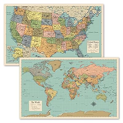
Palace Learning World & US Map Set 18×29
This two-pack set includes a world map and a USA map chart, both in a tan and color design. Each poster measures 18 by 29 inches. The maps feature high-quality 3 MIL lamination for added durability and are tear resistant. The set is designed for educational environments where both global and national maps are needed.
The consistent sizing allows for symmetrical display arrangements on a wall.
- Set of two laminated posters
- Posters are 18 x 29 inches
Palace Learning Equal Earth World & US Set
This set features a world map using the Equal Earth projection, which shows continents at their true relative size. It is paired with a US map, and both posters measure 18 by 29 inches. The maps are laminated with 3 MIL film for durability and are tear resistant.
The Equal Earth projection is a specific cartographic choice that prioritizes accurate area representation. This set is suitable for buyers who value projection accuracy in their wall displays.
- Uses Equal Earth projection for world map
- Includes a US map in the set

Swiftmaps World & USA Classic Premier Set
This two-map set includes a world map and a USA map, each measuring 24×36 inches. The maps are printed on 100lb paper and laminated for dry-erase use. They feature 3D visual terrain relief for both the world and the United States. The set is described as perfect for business, home, or educational use.
The larger 24×36 size provides more detail visibility than smaller formats. The dry-erase capability supports interactive classroom activities.
- Two maps, each 24×36 inches
- Laminated for dry-erase use

Swiftmaps World Classic Premier Map 24×36
This single world map measures 24×36 inches and is printed on 24lb paper. It features a laminated UV coating that allows for dry-erase writing and adds durability. The map includes 3D shaded visual terrain relief for land and oceans. It is designed for business, home, or educational use and is completely current.
The UV coating helps protect the map from fading and wear over time. This format is ideal for buyers who need a single, large world map.
- Laminated with UV coating for dry-erase
- Printed on 24lb paper
Head-to-Head Comparisons
Compact World and US Map Sets
Both the Laminated World & US Map Poster Set and the Palace Learning World & US Map Set offer two posters measuring 18 by 29 inches. Both sets feature 3 MIL lamination and are tear resistant. The primary difference lies in the design and branding of the maps.
The first set is described as updated and high-quality, while the Palace Learning set specifies a tan and color design. Buyers choosing between these two should consider the visual style that best matches their existing decor or classroom theme, as the physical dimensions and durability features are identical.
Swiftmaps Paper vs. UV Coated Maps
The Swiftmaps World Premier Wall Map and the Swiftmaps World Classic Premier Wall Map both measure 24×36 inches and feature 3D shaded relief. The Premier map is printed on 24lb paper and is described as a folded edition, while the Classic Premier map features a laminated UV coating for dry-erase use.
The Classic Premier map is explicitly designed for writing on, whereas the Premier map is a standard paper poster. If you need to write on the map, the Classic Premier is the appropriate choice. If you prefer a standard display map without the dry-erase coating, the Premier map is suitable.
Giant Single Sheet vs. Decorative Medium Map
The Maps International Giant World Map measures 46×80 inches, making it significantly larger than the Rand McNally Classic Edition, which measures 50×32 inches. The Maps International map is a political map with hill and sea shading, designed for large rooms. The Rand McNally map features antique-style accents and an Africa-centered projection, offering a decorative, library-shelf feel.
The Maps International map is better for maximizing wall coverage in large spaces, while the Rand McNally map is better for buyers who prioritize aesthetic design and a specific projection style over sheer size.
Buying Guide
Choosing the Right Map Size
Measure your available wall space before selecting a map. Compact sets like the 18×29 inch options are suitable for smaller classrooms or home offices. Medium-sized maps, such as the 24×36 inch Swiftmaps, offer a standard presence. For large lecture halls or open-plan offices, the 46×80 inch Maps International map provides maximum visibility.
Ensure the map size complements the room's proportions to avoid visual clutter.
Understanding Map Projections
Different projections serve different purposes. The Rand McNally Classic Edition uses an Africa-centered projection, which shows every country intact without edge distortions. The Palace Learning set features an Equal Earth projection, which displays continents at their true relative size. Standard Pacific- or Atlantic-centered maps are common but may distort areas near the edges.
Choose a projection that aligns with your educational or decorative goals.
Lamination and Durability Needs
Lamination adds durability and can enable dry-erase functionality. The Maps International and Swiftmaps Classic Premier maps are laminated for writing with whiteboard pens. The Rand McNally and Palace Learning maps are laminated to resist scuffs and fingerprints. If you plan to write on the map, ensure it is explicitly labeled for dry-erase use.
For display-only purposes, standard lamination provides sufficient protection against wear.
Paper Quality and Print Details
Paper weight and print details affect the map's appearance and longevity. The Swiftmaps maps are printed on 24lb or 100lb paper, depending on the model. The Maps International map features high-level detail with colored countries and clear towns. The Rand McNally map includes color-matched topographical relief.
Higher paper weights generally offer a more premium feel and better resistance to tearing. Consider the level of detail required for your specific use case.
Frequently Asked Questions
Are these maps suitable for classrooms?
Yes, several options are designed for educational use. The Maps International and Swiftmaps Classic Premier maps are laminated for dry-erase writing, making them ideal for interactive lessons. The compact sets are also suitable for smaller classroom sections. Check the specific lamination type to ensure it meets your instructional needs.
What is the difference between a political and physical map?
A political map focuses on boundaries, countries, and cities, as seen in the Maps International map. A physical map highlights terrain features like mountains and elevation, as seen in the Rand McNally and Swiftmaps maps with 3D relief. Some maps combine both elements, offering colored countries and topographical shading for a comprehensive view.
How should I hang a large rolled map?
Large maps like the Maps International 46×80 inch model ship rolled in a tube to prevent creases. Once unrolled, they can be hung using standard wall mounting hardware. Ensure the wall surface is flat and clean to support the weight and size of the map.
Use appropriate hooks or rails to secure the map evenly.
Do these maps come with mounting hardware?
The provided descriptions do not specify if mounting hardware is included. Most wall maps are designed to be hung using standard hooks, rails, or adhesive strips. Check the specific product listing for details on included accessories. You may need to purchase mounting hardware separately depending on your wall type and preferred hanging method.
This article is part of our complete guide Arts, Crafts & Sewing — browse all our comparisons and buying guides.
Last update on 2026-11-18 / Affiliate links / Images from Amazon Product Advertising API